
Phoenix's appeal is real, but after a few days in the valley heat and grid of strip malls, you'll want out. The good news: you don't have to drive far. Within an hour or two, the landscape shifts—pines replace palms, elevation climbs, and you're suddenly in a different Arizona entirely. I've made most of these runs at least twice, usually at times I probably should've stayed home, and every single one delivered something worth the gas money.
The best part about day-tripping from Phoenix is that you're not locked into the resort calendar. You can leave at dawn, be somewhere genuinely remote by mid-morning, and still make it back for dinner. Start planning around season, not just distance—that's the key mistake most people make.
Sedona: The Obvious Call That's Actually Worth It
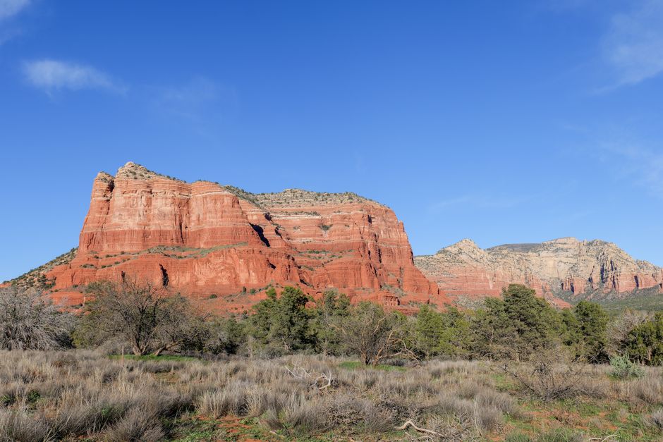
Everyone goes to Sedona, and for once, the hype isn't entirely unfounded. It's roughly 120 miles north, a 90-minute drive up Interstate 17 that climbs from the Sonoran Desert floor into red-rock country. The town itself is overstuffed with art galleries, New Age shops, and restaurants with prices that make you squint. But the land around it is genuinely spectacular.
The hikes are what justify the trip. Cathedral Rock is the shortest and most crowded—maybe 1.2 miles round trip with some light scrambling and views that work for social media. If you want solitude and actual challenge, hit Devil's Bridge (4 miles round trip), which winds through juniper and red dirt before opening onto one of Arizona's best natural arches. The town's also near Oak Creek Canyon, a scenic drive worth taking on the way back even if you skipped Sedona proper.
Timing matters. Winter (November through February) is perfect—cool, no monsoons, minimal crowds before 10 a.m. Summer is a furnace, and April-May brings the worst of both worlds: heat and peak tourists. If you go in fall, go early in the day. The light gets golden by late afternoon but the parking lots fill up by noon.

Flagstaff: Actual Mountains, Real Town
About 140 miles north, two and a half hours minimum depending on traffic and road work. Flagstaff sits at 7,000 feet—cool enough that you'll notice the temperature drop, pine-forested enough that you'll forget you were just in a desert city. The town has bones: a genuine downtown strip on Route 66, local breweries that don't feel like tourist traps, and a student population from Northern Arizona University that keeps it from feeling museum-like.
Walnut Canyon, just east of town, is a smart move for the 2.5-hour slot. It's a 2.4-mile loop that descends through ponderosa forest to a 12th-century cliff dwelling—the Sinagua people built apartments into the canyon wall, and you walk right through them. The trail is well-maintained and rewarding without being grueling. If you're willing to skip the formal hike, the Lowell Observatory (where Pluto was discovered in 1930) is worth an hour, and the views from the rim roads near the San Francisco Peaks are free and stunning.
Flagstaff works year-round, but late spring through early fall is ideal. Winters can bring snow that makes some roads sketchy. Go on a Friday morning if you can swing it—the drive back Sunday evening is genuinely miserable.
Jerome: Ghost Town That Refuses to Die
Jerome is weird, small, and 90 minutes northwest—about 45 miles but the roads wind enough that it takes longer than the straight-line distance suggests. It's perched on Cleopatra Hill at 5,400 feet, a former mining town that nearly disappeared entirely before artists and eccentrics moved in. Now it's got maybe 400 residents, steep narrow streets, and a density of quirky shops and galleries that punch above what you'd expect from the population.
There's no major hiking here, which is almost the point. You park and walk. The old mining equipment still sits around—ore cars, processing plants, general decay that hasn't been sanitized. The views down-valley are excellent. The Verde Valley around it is wine country, casual stuff without the Napa pretension. Grab lunch at one of the few restaurants (standards fluctuate; I'd eat before showing up if you're picky) and browse the galleries. Some are genuinely good, some are exactly what you'd expect from a renovation project.
Season is less critical here since elevation keeps it cooler year-round. Fall through spring is best—summer heat is manageable but unnecessary. Winter occasionally brings ice on the hill roads, which is a pain but not impossible.

Prescott: Cowboy Town With Substance
Prescott is due north of Phoenix, roughly 100 miles and 90 minutes. It sits at 5,400 feet and has been Arizona's territorial capital and, for a while, the entire state's capital. Unlike Jerome, it's a real functioning town with a solid population, decent infrastructure, and a genuine town plaza anchored by the Yavapai County Courthouse.
The plaza itself is worth wandering—there's a roofed bandstand, old saloons and shops, and a relaxed vibe that doesn't feel manufactured. Whiskey Row on the west side of the plaza is the original frontier strip, narrow and old and packed with actual working bars. The Smoki Museum has genuinely good Native American art if you want something structured.
For an actual activity, the Granite Mountain Wilderness north of town offers real hiking. The Granite Mountain Trail itself is about 3 miles to a ridge, climbing through pine and granite with views of the mountains spreading out for miles. It's not famous enough to be crowded, and the elevation keeps you cool even when Phoenix is broiling. A shorter option is the Watson Lake loop, 2.7 miles around a small reservoir with impressive granite formations.
Fall through spring is ideal. Summer is cool by Phoenix standards but still hot by normal ones. Winter's fine but occasionally icy in spots.
Apache Trail and the Superstitions: For When You Want Actual Wilderness
The Apache Trail loops east of Phoenix through the Superstition Mountains, roughly 50 miles but on roads that were engineered a century ago and haven't been modernized since. From Apache Junction (about 40 minutes east on the 60), the scenic loop is maybe 40 miles one way, and it takes forever in the best possible way. The road narrows, paves over to gravel in spots, climbs ridges, and delivers views of some of Arizona's most dramatic interior landscape.
The Superstitions are beloved by hikers but get crowded on weekends at the obvious trailheads. If you're doing the Apache Trail drive, pull off and hit a lesser-known trail—Barks Canyon, Siphon Draw, or even just finding a quiet spot to walk into the desert. Weaver's Needle, the formation visible from multiple points along the trail, is iconic enough to justify the drive on its own.
Lost Dutchman State Park is right there and offers better infrastructure if you want a structured option. The view of the Superstitions from the overlook alone is worth the park fee.
This trip works best in winter and spring. By May, the trails can be genuinely dangerous—heat, minimal water, and zero shade combine badly. October through March is the sweet spot. The drive itself takes most of a day if you're hiking too, so don't plan to leave Phoenix at noon and be back for dinner.

Practical Logistics
Gas prices matter less than you'd think when you're running short distances, but Phoenix traffic in and out doesn't. Tuesday through Thursday mornings offer the clearest routes north. Interstate 17 is your lifeline for Sedona and Flagstaff; US 60 east works for the Superstitions and Apache Trail. Download offline maps because cell service is patchy once you get into canyons. Bring water even on short hikes—the Arizona sun is patient and efficient at dehydration.
Season really does rule these decisions more than most travelers expect. April and May feel like you're doing the right thing and the land is actively disagreeing. October and November are close to perfect across almost all of these—warm enough to be comfortable, cool enough to hike without suffering, and the light is honest.
Most of these trips don't need advance reservations or extensive planning. Park early at popular trailheads, bring sunscreen regardless of what you think the weather will do, and don't underestimate how quickly you lose light in the canyons. You've got plenty of options within shouting distance. The question is usually just which direction you point the car toward.